“Weather AI solution predict future climate crisis”
The paradox of statistics caused by climate data imbalances finds its solution
in satellite imagery and SI Analytics AI solution.

“There is little lie, big lie, and statistics. So, statistic doesn’t help when it comes to non-stationary data series. And in climatology it has always been a problem of attributing extreme events, is it because of the climate change[...]?”
<Vladimir Ryabinin, Assisstant Director-General of the Intergovernmental Oceanographic Commission UNESCO at COP 28-AI/ML solutions for Climate Change Innovation Factory>
On December 2nd, at COP 28, during the ‘AI/ML solutions for Climate Change Innovation Factory’ challenge panel, Vladimir Ryabinin, Assistant Director-General of the Intergovernmental Oceanographic Commission UNESCO, opened his speech by pointing out the paradox of non-generalizable climate data statistics.
UNESCO organized this challenge to address global issues, such as climate disparities in regions caused by data imbalances, seeking solutions through Artificial Intelligence. As a representative case, UNESCO mentioned finding innovative solutions through SI Analytics weather intelligence AI Solutions.

<The importance of Early Warning for All>
Climate change manifests as statistically significant alterations in the long-term average state or variability of the climate. It impacts the natural environment, including the atmosphere, oceans, ecosystems, and society as a whole, and interacts with various environmental and social factors. In essence, climate change refers to the effects of natural or artificially induced climate changes on natural and societal systems.
Imagine if we could identify actions to take before natural disasters caused by climate change occur. Early warnings reduce about 30% of human casualties and facilitate swift responses for recovery in disaster-stricken areas. However, approximately 50% of the world still needs access to early warning solutions, leaving regions like Africa, Southeast Asia, and Pacific Island Nations vulnerable to the direct impact of disasters. To minimize damage and bridge the information gap, SI Analytics introduces a solution contributing to the UN’s ‘Early Warning for All’ initiative, aiming to provide, as the name indicates, early warning capabilities for everyone.

<Climate Crisis Caused by data inequity>
Understanding patterns through periodically collected data to predict climate change is crucial. Unfortunately, we currently live in a world marked by data inequity. Meteorological and climate information reaches us primarily through data collected in areas where weather radar systems are installed, providing us with early warnings and weather updates in our daily lives. However, a common misconception is that everyone worldwide has equal access to this information.
The installation and maintenance of weather radar systems incur significant costs, making it challenging to implement in developing countries and regions. In many areas, especially for developing nations, radar installation is complex due to these high costs. Consequently, regions without radar coverage face significant challenges in receiving accurate early warnings and other weather data, leading to a significantly lowered capacity to prepare for climate change-induced situations preemptively.

To overcome the limitations of meteorological and climate data inequity, an alternative solution is presented through satellite imagery data and predictive technology powered by artificial intelligence. Satellite imagery captures the entire globe, providing high-resolution images at a 2km scale and continuously delivering data at a frequency of minutes.
However, the accumulated terabytes of satellite imagery data are challenging for human analysis alone. Here, the spotlight shines on SI Analytics artificial intelligence solution, which efficiently processes and analyzes vast amounts of satellite imagery data.

<Integrated solutions from precipitation monitoring to recovery as a response to the climate crisis>
SI Analytics has introduced a specific way for its 'Impact-based Forecasting with Weather Intelligence AI Solution' to address the climate crisis challenges. They outlined a roadmap for providing foundational information for typhoon path prediction using solutions like 'GeoCloud,' which predicts cloud movements based on meteorological satellite data, and 'GeoRain,' which offering accurate precipitation monitoring. This integrated solution not only forecasts and monitors weather patterns but also provides predictions for damage measurement related to flooding – predicting the extent of rainfall and its duration. It encompasses a comprehensive approach to prediction, monitoring, and recovery.

Let's take a closer look at each of the specific solutions. 'GeoCloud' is a solution that predicts the movement of clouds by forecasting future weather frames. It determines how threatening the evolving clouds will become and which regions will be impacted.

Next, the precipitation monitoring service, 'GeoRain,' displays results of rainfall monitoring combining Earth observation data with artificial intelligence. This solution contributes to providing precipitation information in countries without radar systems and in maritime areas where deploying radar equipment is challenging. Currently, 'GeoRain' operates using satellite imagery with a spatial resolution of 2 km, derived from geostationary orbit images captured every 10 minutes. The solution utilizes SuperX technology for super-resolution, enhancing spatial resolution through artificial intelligence to provide higher spatial resolution.

In essence, by utilizing GeoCloud and GeoRain together, it will be possible to comprehensively understand approaching typhoons from the sea, predict their path, and observe how precipitation is developing along the path. This service will be integrated into the 'OVISION earth' platform in the first half of next year, providing an amazing amount of meteorological and climate information.

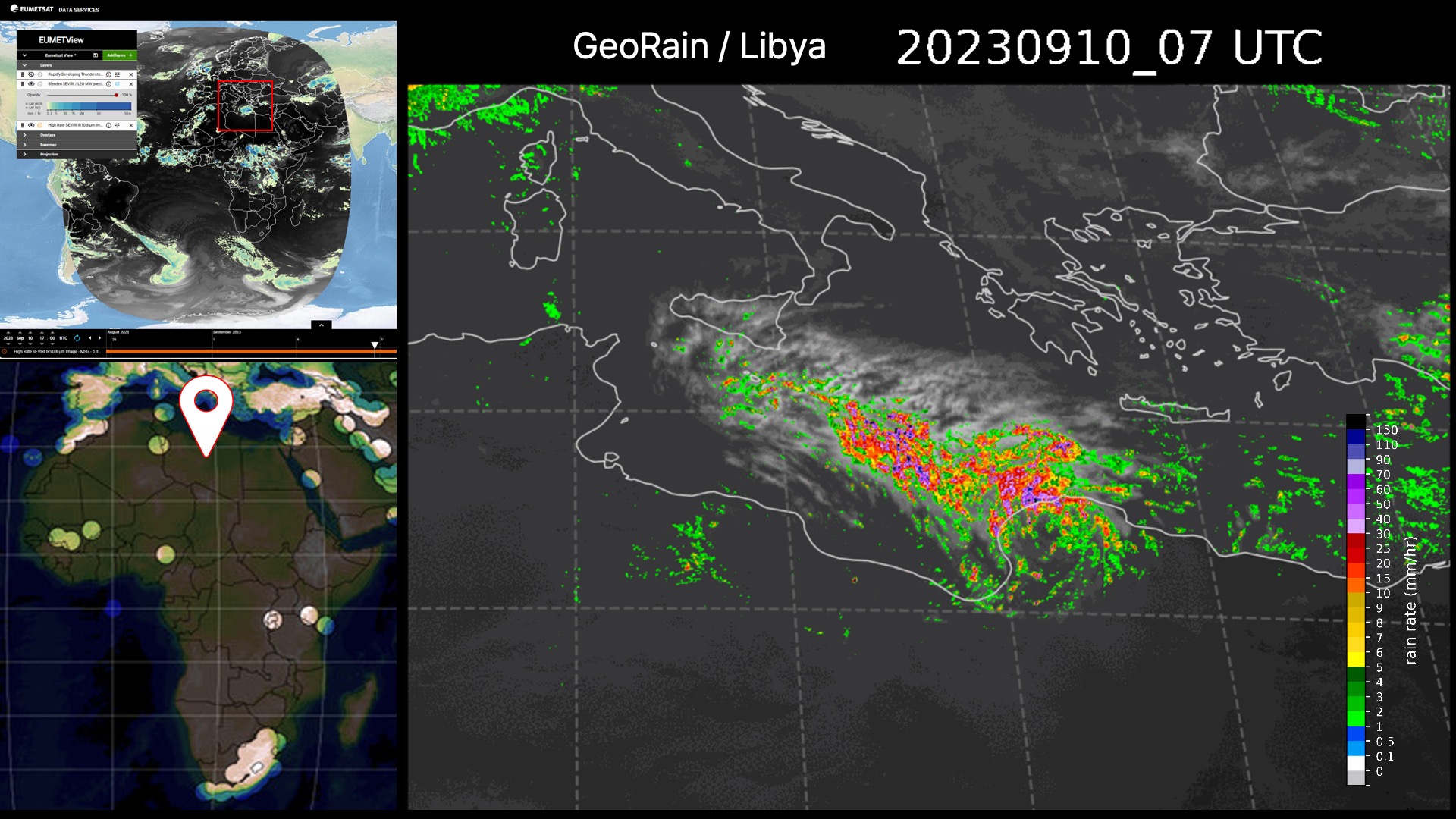
<Catastrophic Libyan floods... can be predicted>
Do you remember the tragically devastating flood that occurred in Libya last September? The large-scale disaster claimed the lives of approximately 20,000 people and left the world in sorrow, turning once beautiful cities into desolated areas. Libya, a region without installed weather radars, faced challenges in responding to floods, highlighting the urgent need for proactive measures in early warning systems. It underscores the importance of providing predictive solutions to regions in need of assistance, aiding in exploring effective response strategies.

The image below represents the results of applying the GeoRain solution to data obtained during the flooding in Libya. Despite Libya being an area without radar sensors, the fact that such results can be achieved demonstrates the scalability of SI Analytics model globally. It highlights that accurate meteorological information can be provided for preemptive responses in any region monitored by weather satellites.
<Addressing the Climate Crisis through Climate AI Solutions>
SI Analytics aims to overcome the global climate crisis by providing early warnings through satellite imagery and AI solutions, ensuring equitable access to climate crisis alerts for all humanity. The goal is to minimize the suffering of those affected by information disparities and to contribute to swift recovery efforts, thereby minimizing asset losses. Building upon this recent challenge victory, SI Analytics seeks to establish a foundation for equal access to climate information and to contribute to global societal responsibility by providing information to the international community."

<Enhancing the Value of Satellite Imagery through Super-Resolution 'SuperX’>
SI Analytics has demonstrated its ability to elevate private satellite capabilities by entering strategic solutions with leading U.S. private satellite companies such as Planet and Maxar. Through successfully implementing the SuperX service, a technology-driven AI-based enhancement for satellite imagery quality, SAIA has contributed to elevating the resolution and analytical value of satellite imagery data. This development allows for the more meaningful utilization of data that captures broad areas with lower resolution, exploring new avenues for leveraging low-resolution images in AI analysis.
By transforming lower-resolution satellite imagery into analytically useful data, resolution becomes a critical factor in determining the effectiveness of AI recognition. SI Analytics contributes to creating an environment where information obtained from Earth observations can be proactively verified, thereby facilitating early confirmation of insights in the field of global observation."

Contact https://www.si-analytics.ai/index_eng.php Email: findout@si-analytics.ai |
Notice
- All rights reversed SI Analytics Co., Ltd.
'Review' 카테고리의 다른 글
| “기상·기후 AI 솔루션으로 극복하는 기후 위기” (0) | 2023.12.05 |
|---|---|
| Brief Review on Anchor-Free Object Detection (2019-2020) (3) | 2022.01.03 |
| 시간에 따른 도시 개발을 추적해봅시다 - SpaceNet 7 수상자 기술 분석 (0) | 2021.06.03 |
| Score-based Generative Modeling by Diffusion Process (4) | 2021.02.15 |
| 라벨 스무딩(Label smoothing), When Does Label Smoothing Help? (2) | 2020.07.15 |


